

Ukraine maps are back
WarMapper control maps for Ukraine will make their return this week.


Ukraine control maps are coming back to the WarMapper social media pages this week, and I will also start to publish summary updates here on Substack.
As there has been a break, I have taken the opportunity to make some changes to the map styling. The war in Ukraine has evolved several times since the outbreak, and the most effective way to map it has had to evolve alongside it.
When the war expanded beyond the Donbas in 2022, advances were rapid and fluid. There was no clear frontline, and maps reflected this reality. Many analysts showed broad operational areas, with only a handful of locations marked as firmly controlled. In some cases, such as Nathan Ruser’s (@Nrg8000) maps, advances were illustrated simply with arrows showing the routes taken by Russian forces.
Early WarMapper maps followed a similar logic. Large areas were marked as forward Russian operating areas to indicate intermittent presence rather than firm control.
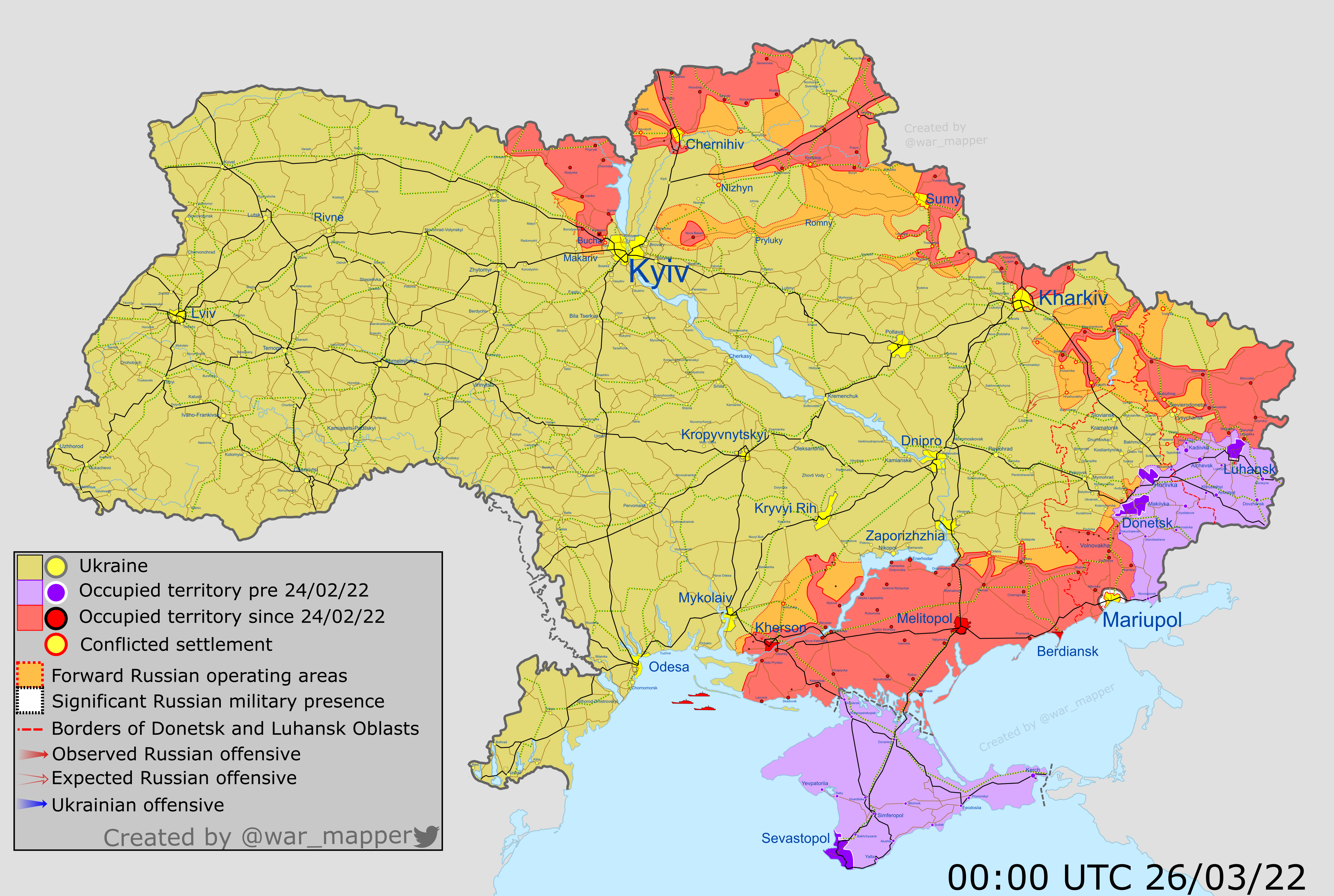
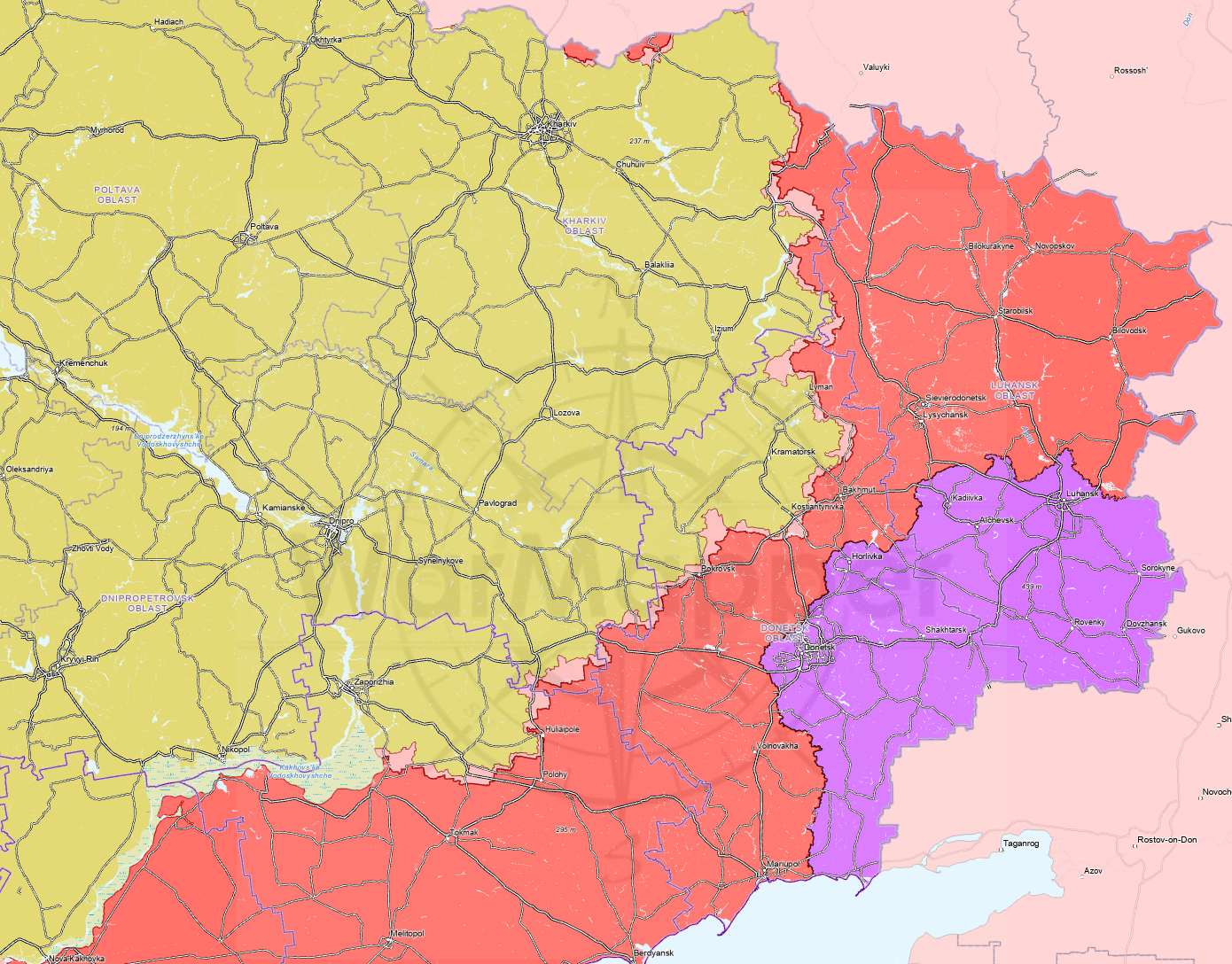
As the war progressed, frontlines solidified. Trench warfare became dominant, advances slowed, and it became possible to map the frontline with high precision, in some areas down to individual treelines or streets.
By the end of my Ukraine mapping last year, that level of precision was already becoming less accurate. The growing impact of drones was already making static positions increasingly vulnerable, and the concept of a clearly defined, continuous frontline was starting to break down again.
Nearly a year on, that trend has accelerated. Drones dominate the battlefield to an even greater degree, which makes firm, unbroken frontlines unrealistic. Areas between positions are increasingly fluid, with presence defined more by activity than permanent occupation.
As a result, bringing back the Ukraine maps has required a change in how control and presence are represented.
So what changes are coming to the Ukraine maps?
Ukrainian control
From now on, maps will show only the presence of opposing forces rather than reaffirming default territorial ownership. For example, inside Ukraine, Ukrainian control will no longer be explicitly marked. Ukrainian territory is treated as the default unless there is a confirmed Russian presence. Ukrainian troops do not need to be physically present for an area to be Ukrainian, only an enduring absence of Russian forces.
The same logic applies in reverse inside Russia, where only Ukrainian presence will be marked.
Forward Operating Areas
The previous “grey zone / contested” designation has been replaced with “Forward Operating Areas”.
This terminology more accurately reflects battlefield reality as there are varying types of greyzone that can expand tens of kilometres from the ‘front’. In this case, a forward operating area indicates any location where hostile forces are actively present or conducting operations, regardless of how secure or permanent that presence may be.
In Ukraine, areas marked as Forward Russian Operating Areas indicate confirmed Russian military activity, including reconnaissance and probing attacks. These markings may persist even if Ukrainian forces also operate in the same area, as the designation reflects ongoing Russian presence rather than exclusive control. If Russian activity ceases and Ukrainian operations continue, the marking will be removed.
This approach avoids automatically marking the entire space between more firm positions as contested, now only marking up until the furthest known Russian advance. Under the old system, all areas between Ukrainian and Russian secure control would have been marked grey, exaggerating the depth of contested territory.
The impact of this change varies across the front. In quieter sectors, forward Russian operating areas may be less than 500 metres deep, while in more active sectors they can extend to several kilometres.
In effect, this should be a relatively minor change, but it will hopefully provide a more realistic picture where there are differences.
Occupied territory
The final major change relates to how occupied territory is confirmed.
Currently, forces may operate in an area regularly without maintaining a permanent presence. Units rotate in and out, while opposing forces may also move through the same space for resupply or rotations of their own. As a result, confirmation of firm control often takes longer than it did earlier in the war.
This means occupied territory markings will update more slowly than in previous versions. However, the use of forward operating areas ensures that active Russian reach is still accurately represented, even where the degree of control remains uncertain.
Project Owl geolocations

Updates for Ukraine will now rely primarily on the open-source geolocations completed by volunteers and collated by Project Owl. This data will be supplemented by additional information I source independently, but Project Owl’s dataset will form the core of the update process.
This avoids unnecessary duplication of effort and allows for regular Ukraine updates while leaving time for continuation of other mapping projects.
Other changes
Some other minor changes have been made to the visuals and data sources. This includes rail lines, roads, and waterways. Which should now all be more clearly and precisely marked than previously.
There aren’t too many changes to the colour palette, and I have made an effort to ensure that the map is still accessible for those with colourblindness. That being said, the tools are not always perfect, so if you spot any issues in that regard, please don’t hesitate to let me know, and I will make the fixes.
As always, I am open to suggestions, feedback, or corrections on all the maps.
End-of-month data sets.
While the Ukraine map itself has been brought up to date, the timings of advances to the current positions are still being reviewed and recorded. While the end-of-month charts and summaries will return to the page, the historical data is not yet ready to share.
The charts will be posted for all for free here on Substack, the website, and across the social media pages. Paid subscribers will also get access to the underlying raw datasets.
Suggestion: mark the oblast boundaries clearly, eg in bold
Good to have you back.